


monsols

jpfrobert
User
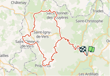

Length
51 km

Max alt
742 m

Uphill gradient
1004 m
Km-Effort
64 km

Min alt
429 m

Downhill gradient
1003 m
Boucle
Yes
Creation date :
2018-06-26 15:28:45.929
Updated on :
2018-06-26 15:28:45.929
3h35
Difficulty : Difficult

FREE GPS app for hiking
 SityTrail
IGN / Geographical institutes
SityTrail Plus
The world is yours!
About
Trail Cycle of 51 km to be discovered at Auvergne-Rhône-Alpes, Rhône, Les Ardillats. This trail is proposed by jpfrobert.
Positioning
Country:
France
Region :
Auvergne-Rhône-Alpes
Department/Province :
Rhône
Municipality :
Les Ardillats
Location:
Unknown
Start:(Dec)
Start:(UTM)
618590 ; 5118146 (31T) N.
Comments